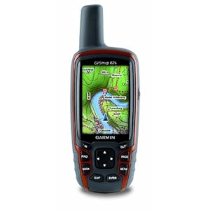
Garmin eTrex 30 vs GPSMAP 62s
A Comparison of the differences feature between Garmin eTrex 30 and GPSMAP 62s
| Garmin Handheld GPS | 
eTrex 30 |

GPSMAP 62s |
| Garmin eTrex 30, Worldwide |
Garmin GPSMAP 62S Handheld GPS Navigator |
|
| The Difference Features | 1. Unit dimensions, WxHxD: 2.1″ x 4.0″ x 1.3″ (5.4 x 10.3 x 3.3 cm) 2. Display size, WxH: 1.4″ x 1.7″ (3.5 x 4.4 cm); 2.2″ diag (5.6 cm) 3. Display resolution, WxH: 176 x 220 pixels 4. Weight: 5 oz (141.7 g) with batteries 5. Battery life: 25 hours 6. Interface: USB |
1. Unit dimensions, WxHxD: 2.4″ x 6.3″ x 1.4″ (6.1 x 16.0 x 3.6 cm) 2. Display size, WxH: 1.43″ x 2.15″ (3.6 x 5.5 cm); 2.6″ diag (6.6 cm) 3. Display resolution, WxH: 160 x 240 pixels 4. Weight: 9.2 oz (260.1 g) with batteries 5. Battery life: 20 hours 6. Interface: high-speed USB and NMEA 0183 compatible |
| YouTube Video Demo / Review |
|
|
| Price Check |
|
|
Common Features for both Garmin:
- Display type: transflective, 65-K color TFT
- Battery: 2 AA batteries (not included); NiMH or Lithium recommended
- Waterproof: yes (IPX7)
- High-sensitivity receiver: yes
- Basemap: yes
- Ability to add maps: yes
- Built-in memory: 1.7GB
- Accepts data cards: microSD™ card (not included)
- Waypoints/favorites/locations: 2000
- Routes: 200
- Track log: 10,000 points, 200 saved tracks
- Automatic routing (turn by turn routing on roads): yes (with optional mapping for detailed roads)
- Electronic compass: yes (tilt-compensated, 3-axis)
- Barometric altimeter: yes
- Photo navigation (navigate to geotagged photos)
- Custom maps compatible: yes
- Geocaching-friendly: yes (paperless)
- Hunt/fish calendar: yes
- Sun and moon information: yes
- Tide tables: yes
- Area calculation: yes
- Custom POIs (ability to add additional points of interest): yes
- Unit-to-unit transfer (shares data wirelessly with similar units): yes
- Garmin Connect™ compatible (online community where you analyze, categorize and share data): yes
Unavailable Features:
Both eTrex 30 and GPSMAP 62s do not have the following features:
- Floats
- Preloaded maps
- Touchscreen
- Camera
- Picture viewer
- Outdoor GPS games
Disclaimer: Information provided is believed correct and true to the best of our ability, however, Galileo GPS Solutions is not responsible for typographical errors or incorrect data. To report any errors, please use the comment below or visit the official Garmin products page for details specifications.


